Tuesday 20 December 2011

Masters in GIS & Archaeology (MSc) to start at Edinburgh University

0 comments


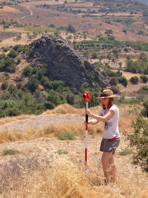
     From September 2012 the University of Edinburgh will be launching a new masters programme - GIS & Archaeology. 

     "The GIS & Archaeology programme at Edinburgh is unique. It builds on our reputation as a centre of excellence in Geographical Information Science (GIS), with a pedigree in archaeological teaching and research which extends back into the 19th Century. It is designed to combine GIS and archaeology into a programme with a distinctive Scottish flavour, while being outward-looking and encompassing international perspectives."

     This is a masters I can thoroughly recommend, with a programme of courses that will be both challenging and rewarding. An understanding and firm technical grasp of the use of GIS in archaeology will set students up for the commercial workspace as well giving them a much needed edge over recent archaeology graduates at a time when employment can be hard to come by.

Wednesday 5 October 2011

New Background Maps in ArcGIS

0 comments


   Esri has launched a series of new background 'canvas' maps. These can be loaded into the newer versions of ArcGIS and provide a less cluttered mapping option. Check out the link below to visit the ESRI Mapping Center and a discussion on the new features;


Tuesday 4 October 2011

The Mannahatta Project - GIS and 3D landscapes

0 comments
    TED talks are amazing!! The fact I can watch them on my huge TV via my Apple TV or Wii makes the experience even better (not to mention the excellent iPhone app). This talks looks at the use of GIS and 3D modelling to genertate the historic landscape of Manhattan prior to the settlement we are used to.

    "400 years after Hudson found New York harbor, Eric Sanderson shares how he made a 3D map of Mannahatta's fascinating pre-city ecology of hills, rivers, wildlife -- accurate down to the block -- when Times Square was a wetland and you couldn't get delivery."

Wednesday 21 September 2011

GIS Cloud Starts HTML5 Mapping Revolution!

0 comments

GIS Cloud Starts HTML5 Mapping Revolution! 


  One of the biggest benefits of vector mapping is interactivity. The map is not just a flat raster anymore, it’s a fully interactive surface. Each object can be clicked and styled dynamically, and gives hover feedback!


  HTML5 is great for mapping not only because it can render maps very quickly, but also because it is a standard. It works on the desktop, on the web, on smartphones and on tablets which means your GIS can work on those devices as well! No need to build native apps for each of those platforms, with HTML5 you get high performance right from the browser.

Thursday 15 September 2011

Are the Ice Sheets shrinking??

0 comments


According to the Times Comprehensive Atlas Of The World the Greenland ice sheet and Aral Sea are shrinking. But is this just an error on their part by misinterpreting ice sheet data. There's already much debate amongst glaciologists I know.

Monday 18 July 2011

Revolver Maps

0 comments


  A very cool display of hits to your website. I'll be adding it soon. You can even click on the globe and revolve it!

Thursday 14 July 2011

Swinglet - The easy to use flying camera

0 comments


This is awesome!!! I really want one. How cool would it be to have one of these flying over our archaeological sites. Watch the video on the page to see how it works!

Saturday 2 July 2011

ArcGIS for home use available for only $100 for a 12 month licence

0 comments


ArcGIS for Home Use makes GIS available to everyone. This offer is ideal for individuals who want to expand their GIS skills. Anyone can participate in this program.
For a $100 annual fee, the ArcGIS for Home Use 12-month term license includes:
  • ArcView
  • ArcGIS 3D Analyst
  • ArcGIS Geostatistical Analyst
  • ArcGIS Network Analyst
  • ArcGIS Publisher
  • ArcGIS Schematics
  • ArcGIS Spatial Analyst
  • ArcGIS Tracking Analyst
The ArcGIS for Home Use program is available worldwide. Customers in the United States can order it online. Customers outside the United States should contact their local distributor.

Wednesday 22 June 2011

Globally available 30m Digital Elevation Models (DEMs)

0 comments


The instructions for use are very simple and the resulting download can be opened in ArcGIS 

How to select a desired area; 
Step 1 :   Define the area of interest by specifying location name, selecting  or  , click and drag a rectangle or polygon  , or input coordinates by selecting  .
Step 2 :   Click Log In and sign on using your WIST/ECHO account.
Step 3 :   Click Download , specify data name, projection, format and other output setting, then submit the request.
Step 4 :   Preview and download Save the output data.

Sunday 29 May 2011

Intrasis for Archaeological excavations

0 comments


Intrasis is an acronym for Intra-site Information System and is a GIS system suitable for all kinds of archaeological documentation, at the site as well as for post excavation work. The system includes two software products, Intrasis Explorer and Intrasis Analysis.

Intrasis Explorer is the core of the system and is used for import of measurement files from different kind of measurement instruments e.g. total station or GPS. All registration of information is done in Intrasis Explorer. It features functions for creating, administer and communicate with the site database, which is stored in MS SQL Server.

Intrasis Analysis is a tool for analysing data created with Intrasis Explorer. Wizards for the most commonly used GIS analysis simplify the GIS work for the archaeologists. Data can be exported to be used in other softwares, for publication or advanced GIS analysis.

I'm just about to install ArcGIS 10 onto my laptop and am gonna give this a whirl!!! 


Wednesday 25 May 2011

Making colour blind friendly maps

0 comments


Maybe an overhaul of colour schemes used by cartographers can enable the likes of Ian Hill to read a map properly :) 

Tuesday 24 May 2011

Nottingham Caves Surveyed in 3D

0 comments


         The Nottingham Caves Survey is using 3D laser scanners to map nearly 500 man-made caves under the city centre.


Saturday 21 May 2011

Magellan Toughcase for the iPhone

0 comments


    Magellan Toughcase for the iPhone. I've just purchased one of these. It provides an accuracy of 3-5 metres to any app within the iPhone. There are several excellent GIS applications for the iPhone;


Monday 16 May 2011

The Archaeological Blogosphere

1 comments


The archaeological blogosphere is strangely beautiful. The Electric Archaeologist has generated this by scraping over 8000 pages from a Google Search of ‘Blogging Archaeology’. 

Sunday 15 May 2011

Archaeological survey and recording made easy

0 comments


Four videos showcasing different archaeological surveying and recording techniques were launched online on 11 April, 2011, and are available to view and download from the Scotlands Rural Past website, YouTube and Vimeo. 

A digital archive for Cyprus’ antiquities

0 comments

The Cyprus Archaeological Digitisation Programme (CADiP) was started in order to manage thousands antiquities scattered all over Cyprus “and serve the needs of the Antiquities department as well as those of researchers and the public,” Curator of Antiquities Despo Pilides said yesterday at a news conference.

A Geographic Information System, in essence a digital map of antiquities, will interface with all existing information on the catalogued antiquities making access and research much easier.

Ipads Help Archaeologists

0 comments


Excavators at Pompeii are using iPads to assist in the recording of features.